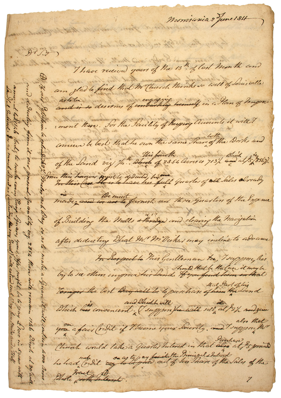
Morris letter to Attwater, 1811
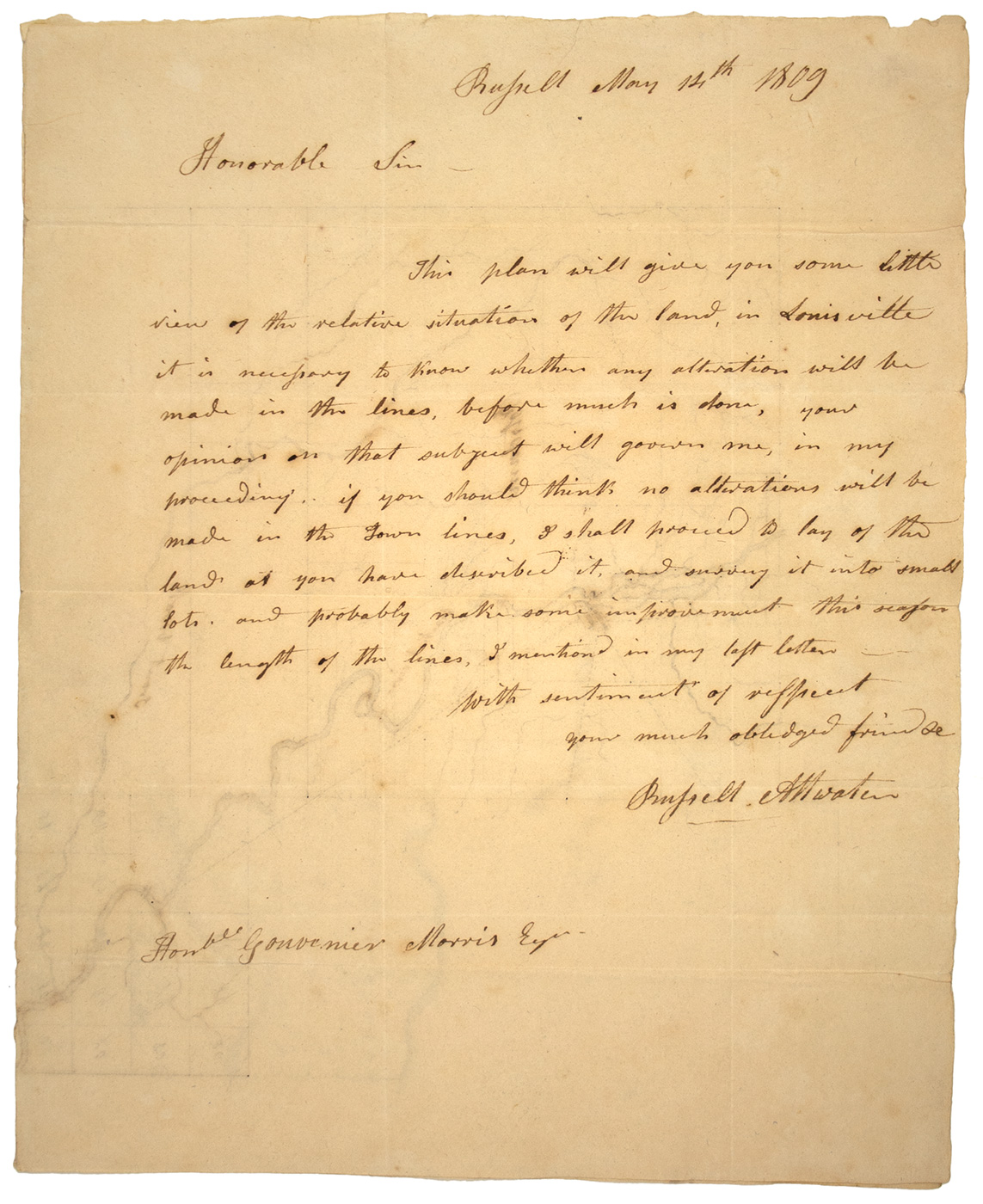
Attwater’s letter to Morris, 1809
Gouverneur MORRIS (1752-1816) Signer and framer of the United States Constitution and signatory to the Articles of Confederation. Fine content draft Autograph Letter, 3pp. 305 x 215 mm. (12 x 8 3/8 in.) Morrisania, 2 June 1811 to Russell Attwater concerning his plans to subdivide and market land around Louisville, New York just to the south of the St. Lawrence River. Together with Russell ATTWATER (1762-1851) Autograph Letter Signed “Russell Attwater”, 1p. 250 x 203 mm. (9 7/8 x 8 in.) Russell, [N.Y.] 14 May 1809 with integral transmittal leaf addressed to Gouverneur Morris with the interior of the bifolium letter sheet bearing a detailed manuscript map of Potsdam and Louisville, New York delineating Morris’ lands in Louisville, New York. One of the earliest detailed maps of this region, including property divisions in Potsdam to the south well as the course of the Raquette and Grasse Rivers. An informative pair of letters between Gouveneur Morris and Russell Attwater, his agent in St. Lawrence County, New York. In 1787, Alexander Macomb purchased a large tract in present-day St. Lawrence County. He appointed Morris as his attorney in 1792 to help develop the tracts. Morris himself purchased a 2,854 acre tract in the southwest corner of Louisville on 15 December 1803.1 Morris turned to Russell Attwater, a recent migrant from Massachusetts to help facilitate land sales and develop mills and other improvements to the land.
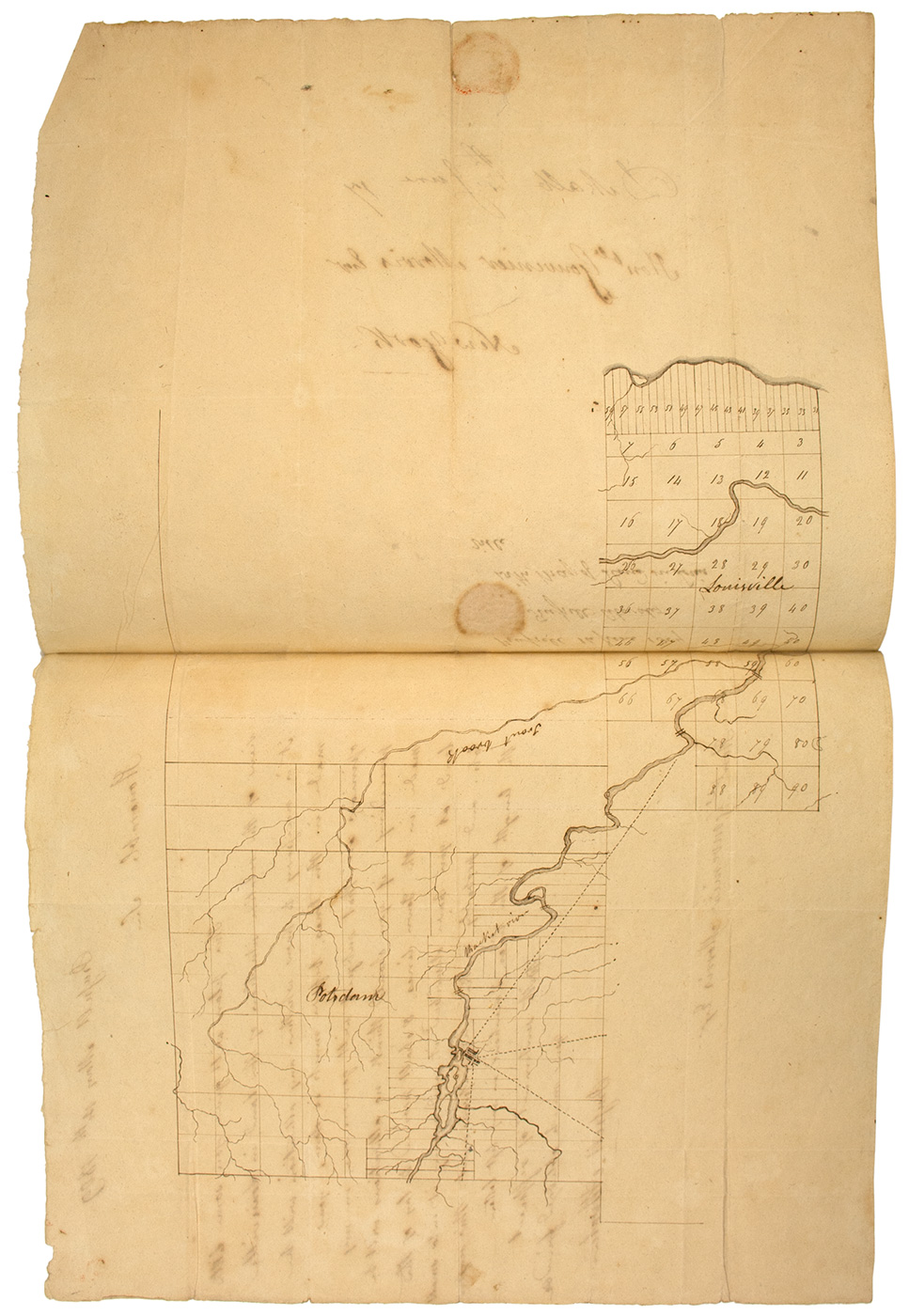
Attwater’s 1809 map of Potsdam & Louisville, NY
Morris’ 1811 draft advises Attwater on a variety of matters including a proposed deal to purchase an adjoining tract with James McVicker, then sell it to a millwright by the name of Church at double the cost. Morris also facilitates Attwater’s access to cash in order to develop the region and offers his advice on the best placement for a mill on the Raquette River. He writes (and for clarity’s sake we only include his edited text) that he is,”glad to find that Mr Church thinks so well of Louisville as to be so desirous of engaging in a Plan of Improvement there. for the facility of Keeping Accounts it will I conceive be best that he own the same share both of the Works and the Land viz 1/4th His fourth of 2854 Acres is 713 1/2 which at $5 is 3567 1/2 from this however[?] presently deducted his quarter of all Sales already made. We must furnish our three quarters of the Expence [sic] of Building the Mills & Bridge and clearing the Navigation after deducting what Mr. McVicar [sic. James McVicker] may incline to advance This Gentleman, I suppose, lies by to see others improve his Land should that be the Case it may be best to purchase that Part of his Land which is convenient and which he will (I suppose) sell at $2 1/2 on a fair Credit if I become your Security. I suppose also that Mr. Church would take a Quarter Interest in that Purchase at $5 provided he had such Credit as to pay the Principal & Interest out of his Share of the Sales of the whole Tract. I understand from your Letter that Mr Church means to pay the $3567 1/2 in Cash or what is equivalent viz in creating the Dam Bridge and Mills. It will be proper for the Sake of Regularity that his Sum and any other Sums which you may have received (deducing his 1/4) be brought to the Credit of the Account of our joint Concern and that Interest being calculated on the Cost a Ballance [sic] be struck which will then be the new Capital or Cost of over 3/4 being 3/8 instead of 4/8 of the whole. This Money so credited will of course be payable to me and from it my 3/8 of the Cost of the Mills &c. But you may perhaps have expected that a Part (perhaps the whole) of your share of the Improvement should be taken from the Sum so payable by Mr Church. If so I shall not object but in that Case it will be proper that you give me your Bond for Whatever Sum may thus be applied to your Use. this must be convenient to you because the Rents and Profits of the Mills will of Course exceed the Interest of the Cost. Mr Church being a good Millwright and therefore a perfect Judge of the Power of Water it would be absurd for me (who have never seen the spot) to give an opinion. I will hazard however to say that (generally speaking) A Bridge below a fall which breaks the ice is more secure than above it That A Dam above a fall is more secure than below it because to produce the same Head less Height is required, and that Mills fed by Race Ways are less exposes to the Rage of rivers than such as adjoin the Dams. The Inconvenience of frost may be obviated by laying Pipes under Ground for the Race Ways which filling a Penstock will give the Power required for overshot undershot or Breast Wheels as may best suit the Machine.” Morris then opines on the merits of the various types and their application for grist versus saw mills, but thinks the better of it and deletes the sentence. After Morris left the U.S. Senate in 1803, he mainly concerned himself with matters related to New York State’s vast interior. He was one of the early proponents of constructing a canal connecting the Hudson River with Lake Erie. Mindful of the young nation’s potential (“the proudest empire in Europe is but a bubble compared to what America will be, in the course of two centuries, perhaps of one”) 1810 to 1813, Morris chaired the Erie Canal Commission. and at the same time he sought to profit from the growing settlement and natural resources available. Attwater’s letter, dated two years before presents the map accomplished on the reverse side: “This plan will give you some little view of the relative situation of the land in Louisville it is necessary to know whether any attention will be made in the lines, before much is done, your opinion on that subject will govern me, in my proceeding. if you should think no alterations will be made in he Town lines, I shall proceed to lay of the land as you have described it and survey it into small lots and probably make some improvement this season the length of the lines, I mentioned in my last letter.”
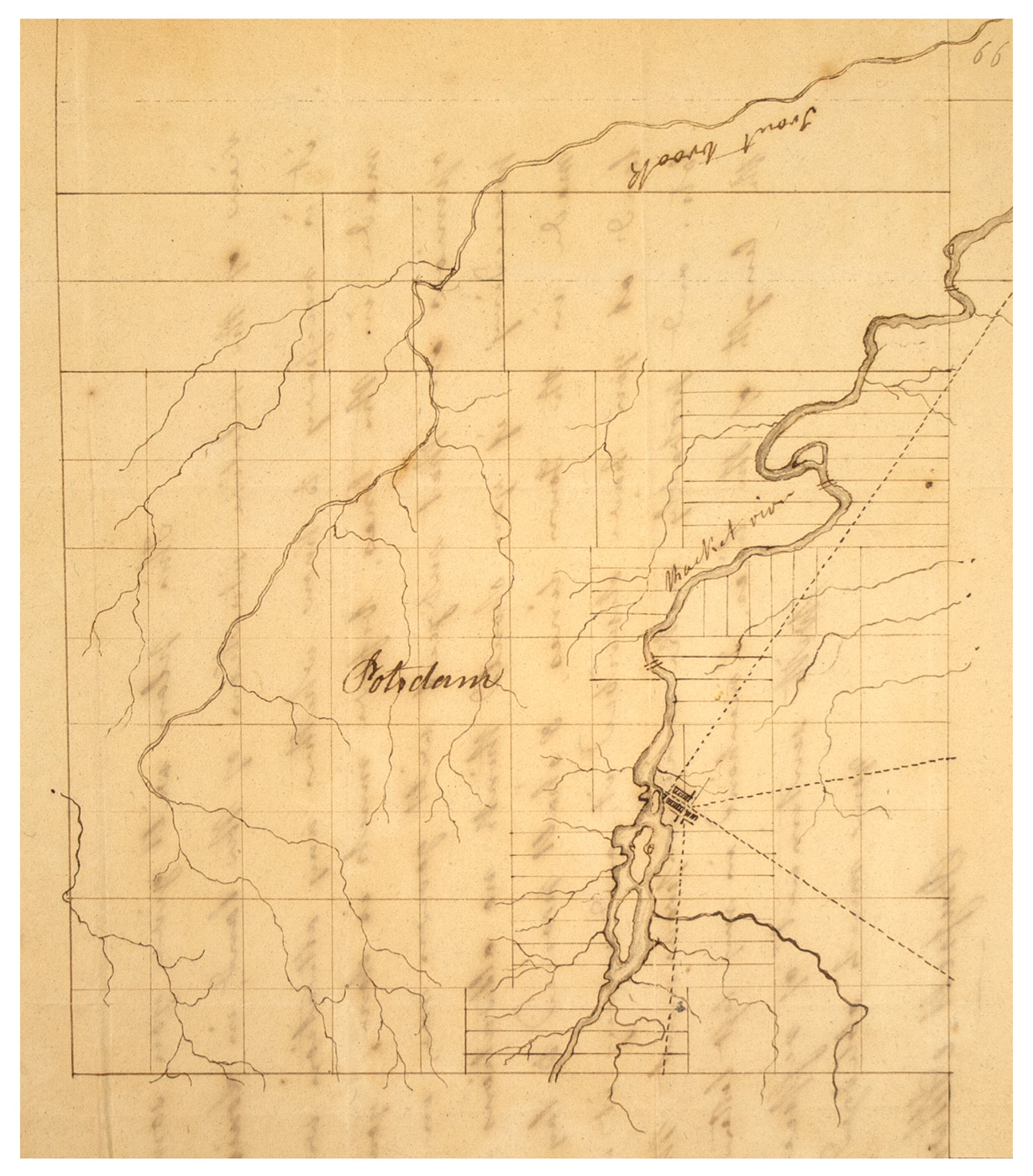
detail of Attwater’s 1809 map of Potsdam, NY
The map Attwater drafts for Morris’ benefit is a fine example of draftsmanship and appears to be one of the earliest detailed maps of this region.2 The map depicts the sectional boundaries of Louisville with their number designations as well as the property divisions in Potsdam. Attwater also traces (fairly accurately) the course of the Raquette and Grasse Rivers as well as the south bank of the St. Lawrence River. Along the route of the Raquette (or “Racket” as it appears on the map), Attwater has added double lines to denote falls. It is likely that Morris used this map when referencing his discussion concerning the placement of mill in his 1811 letter to Attwater. Interestingly, it appears that Attwater may have constructed a mill on the Raquette River near present-day Norfolk, New York, which had been previously known as Atwaters [sic] Falls.3 The remnants of a mill seat are still present along that section of the Raquette River. Born to Reuben Attwater (1728-1801), Russell Attwater was a partner with his father in a mercantile concern in Blandford, Massachusetts until 1799. For several years, Russell carried on a partnership with Moses A. Bunnel which was dissolved in 1803. Sometime afterwards, Russell moved to St. Lawrence County where he helped found several towns including Russell, New York. He did much to promote and improve the region, organizing roads, constructing mills, as well as holding various public offices.4
Rough margins, expected folds, some minor bleed through, else very good.
(EXA 5037) SOLD
__________________
1↩ Gates Curtis, ed., Our County and It’s People: A Memorial Record of St. Lawrence County, New York. (1884), 83.
2↩ The earliest published map that includes any significant detail in the region that we have was Simeon De Witt’s landmark work: A Map of the State Of New York. 3↩
David H. Burr, Map of the County of St. Lawrence (1829). 4↩
Federal Spy, (Springfield, Mass.), 17 Sept. 1799, 4; Republican Spy (Northampton, Mass.), 13 Dec. 1803, 4; Cabinet (Schenectady, N.Y.), 14 April 1813, 3: advertisement soliciting a road builder to construct a road from Wellstown to Russell, N.Y.; Curtis, 526-532.